Subsurface Mapping Support Services
The Goal Of Subsurface Mapping
Subsurface mapping plays a critical role in identifying and understanding the geologic and hydrological controls on the physical and chemical transport of groundwater. BESST can provide a number of different subsurface mapping support services such as cross-section analysis; isopach maps of sedimentary thickness; contour maps of contaminant levels and water levels; and much more.

Commonly, in an attempt to avoid costly treatment options, BESST performs well diagnostics to collect depth-dependent data on flow and chemistry to help inform the water purveyors on potential pathways for well rehabilitation and-or modification. More importantly, BESST’s depth-dependent diagnostic data can be combined with other important well-field information such as geophysical logs, lithological logs, well and pump construction information, and water levels which can assist in bridging the knowledge gap between well dynamics and contamination to aquifer dynamics and contaminant plumes. These subsurface mapping support services enable water purveyors to not only enhance their knowledge of the underlying aquifer(s) system but also, contribute economically valuable information on where to drill new production wells and where to avoid drilling new production wells, what remaining wells to install packers on and where to install them, what wells to repurpose for collection and-or injection, and more.
Isopach Maps
Isopach and Contour Maps
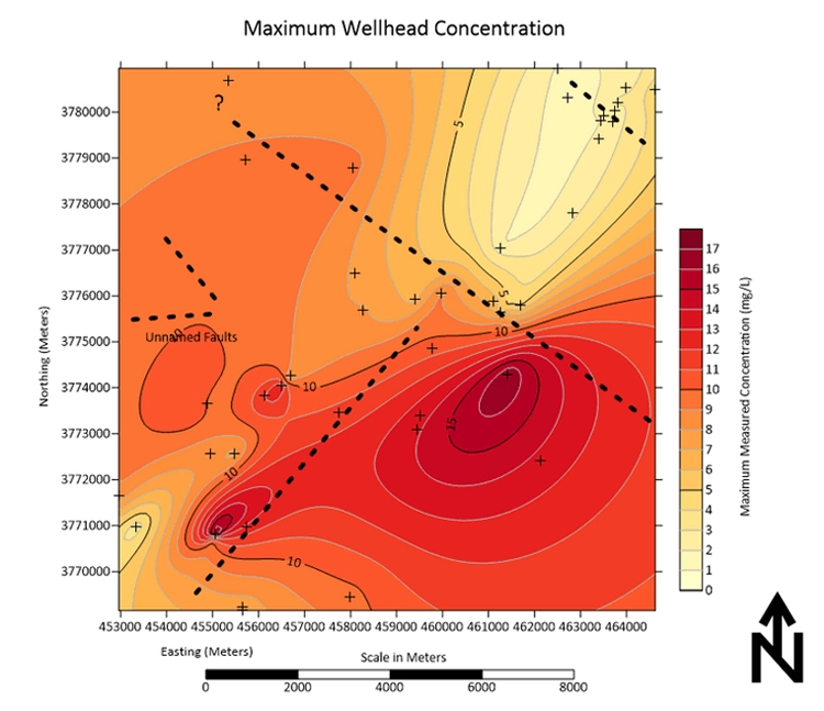
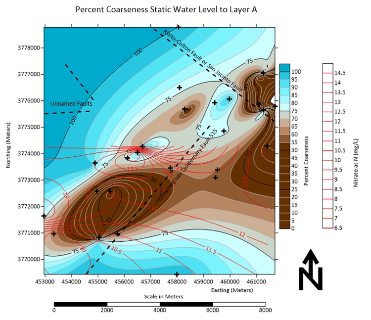
Isopach maps present the percent coarseness for each hydrostratigraphic layer within the well-field study area and are generated using Surfer a Golden Software program. The percent coarseness for each layer is important to know because it indicates the potential amount of aquifer and aquatard material within each layer of the well-field. In addition, contour maps of contaminant levels can be generated and superimposed on top of the isopach maps in order to compare percent coarseness to the concentration gradient across the well-field. This relationship is significant because most groundwater contamination occurrences and distributions are influenced by thick fine-grained units such as clays and silt beds. Therefore, mapping the contaminant levels in conjunction with percent coarseness provides a broader understanding of what areas and which layers are most heavily affected by contamination and why.
Cross-Sections
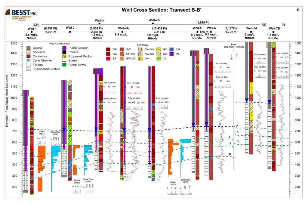
Cross-sections present two-dimensional previews of the subsurface and are generated using Strater a Golden Software program. BESST uses cross-sections to identify and differentiate key hydrostratigraphic layers by using correlations among well and pump constructions, lithology logs, geophysical logs, and dynamic flow & depth-dependent chemistry. Cross-sections are of economic value to water purveyors because they provide insight into the underlying occurrences of contamination and the physical or chemical controls on groundwater flow and contaminant transport without performing downhole diagnostics for each well within the field of study. More importantly, the cross-sections define lithologic boundaries that apparently attenuate contaminant levels with depth thus illustrating a potential target depth for well modification through the use of inflatable packers.
Drill Site Identification
BESST finds subsurface mapping to be of economic value to the water purveyor because it can identify new drilling sites and simultaneously pinpoint what areas to avoid drilling new wells. Furthermore, subsurface mapping can help determine favorable locations for packer installations in an effort to avoid treatment without performing downhole diagnostics for the entire well-field; and provide insight into which wells can be repurposed for mitigating contaminant transport and achieving aquifer rehabilitation. The subsurface mapping support services BESST provides build upon creating pragmatic solutions and recommendations that care for the client’s concerns and bottom line.
Contaminant Contour Maps
Coming soon. If you have any questions, please contact us
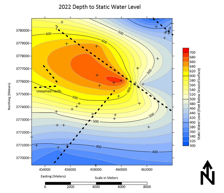
Water Level Maps
Coming soon. If you have any questions, please contact us